
Circuit de l'Est
France, August 7th - 17th, 1910
France, August 7th - 17th, 1910
The Circuit de l'Est course
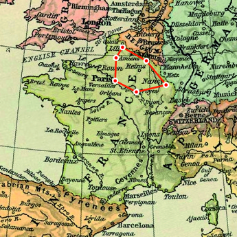
The course went through several iterations during the preparations. Dijon appears to have been dropped early, and the committee also, after listening to the aviators, decided to abandon the stop in Belfort, which would have required a dangerous flight over the mountainous Vosges region to reach Nancy. A stop at Reims was added.
The town of Douai, which already had a working airfield at La Brayelle, was disappointed that neighbouring Lille, where a new airfield would have to be prepared, had been proposed. Different solutions were put forward, including a special stage Douai-Lille-Douai, but in the end, Douai was chosen as staging town.
Reims was replaced by Mézières-Charleville, which is situated further to the north and therefore made the course somewhat shorter.
The final course was presented on June 16th: Paris - Troyes - Nancy - Mézières-Charleville - Douai - Amiens - Paris, six stages, officially totalling 785 kilometres.
The final list of airfields was published on July 26th. In the following days, long lists of the villages and towns that would be passed by the flyers were published. The course was marked with flags on church towers and other prominent buildings. On the right side of the course, it would be marked with red flags with white bands, on the left side with white flags with red bands. All in all, more than 400 such flag posts were listed.
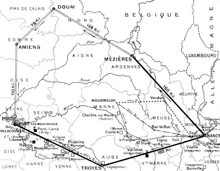
A map of the course, including some of the stops of different pilots during the first two stages. (1)
Stage 1: Paris - Troyes, 135 kilometres

The marked course of stage 1. North is at one
o'clock. (2)
Click here for a high-resolution version!
Click
here for a high-resolution version!
To see more details, open the map in Google Maps by
clicking the "full screen" symbol at the top
right of the menu bar!
Stage 2: Troyes - Nancy, 160 kilometres

The marked course of stage 2. North is at eleven
o'clock. (2)
Clickhere for a high-resolution version!
Click
here for a high-resolution version!
To see more details, open the map in Google Maps by
clicking the "full screen" symbol at the top
right of the menu bar!
Stage 3: Nancy - Mézières-Charleville, 160 kilometres

The marked course of stage 3. North is at five
o'clock. (2)
Clickhere for a high-resolution version!
Click
here for a high-resolution version!
To see more details, open the map in Google Maps by
clicking the "full screen" symbol at the top
right of the menu bar!
Stage 4: Mézières-Charleville - Douai, 140 kilometres

The marked course of stage 4. North is at eleven
o'clock. (2)
Clickhere for a high-resolution version!
Click
here for a high-resolution version!
To see more details, open the map in Google Maps by
clicking the "full screen" symbol at the top
right of the menu bar!
Stage 5: Douai - Amiens, 80 kilometres

The marked course of stage 5. North is at two
o'clock. (2)
Clickhere for a high-resolution version!
Click
here for a high-resolution version!
To see more details, open the map in Google Maps by
clicking the "full screen" symbol at the top
right of the menu bar!
Stage 6: Amiens - Paris, 110 kilometres

The marked course of stage 6. North is at three
o'clock. (2)
Clickhere for a high-resolution version!
Click
here for a high-resolution version!
To see more details, open the map in Google Maps by
clicking the "full screen" symbol at the top
right of the menu bar!
Back to the top of the page